In Ancient Apocalypse, Graham Hancock presents evidence of astronomical alignments for many archaeological sites, including the temples of Malta, various pyramid complexes, and for North American mound sites. Perhaps his most detailed discussion of astronomical alignment is about Poverty Point, a site in modern-day Louisiana that contains many large earthen mounds and a semi circle of ridges.
Astronomical alignments with solstices and equinoxes, or with the rising and falling of particular stars and constellations, have often been proposed in archaeology, and some of them are clearly real. Perhaps the most well-known is the Stonehenge alignment with the summer solstice.
It isn’t surprising that humans would have become concerned with tracking the sky early on, because so much of our survival, whether we are agriculturalists, hunter-gatherers, or something in between, depends on knowing what time of year it is. But these proposed alignments remain easy to propose and difficult to evaluate.
Brecher and Haag (1980), who are proponents of solar alignments at Poverty Point, give a caveat that there are many objects in the sky, and many potential alignments that can be found, even if they were not intended by the builders of a site:
“These could include maximum horizon excursions of the sun (solstice sunset directions), maxim and minimum horizon excursions of the moon, equinoctial solar alignments, and the rise and positions of any number of stars, constellations, star groupings and planets-all astronomical phenomena claimed to have been included in the orientations of buildings, streets, and other structures at a number of ancient sites around the world”
Brecher and Haag initially proposed that the “aisles”, or breaks between the ridge segments at Poverty Point, aligned with solstices and equinoxes if one stood at the centre of the semi-circle (or half-ovoid) that they form. These alignments were soon challenged (Purrington 1983), and eventually rejected. Romain and Davis (2011), using a new mapping of the site using LiDAR, note that they are sometimes off by up to six degrees.
But Romain and Davis propose an alternative set of alignments, which Hancock seems to follow. As always, the problem is not coming up with the idea of an alignment, but rather evaluating it. Even if the site is astronomically aligned, does that reflect the intent of the builders? Lets have a look.
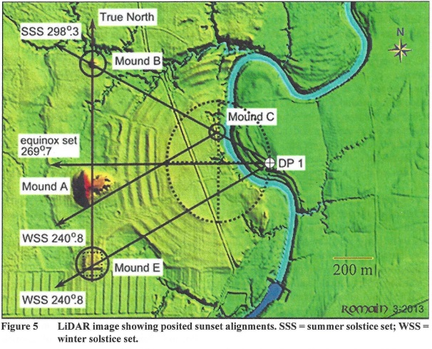
From Romain and Davis 2011
First, they propose that the entire site is oriented to true North (or the north star), which seems reasonable enough. A line drawn from Mound E to Mound B does go through a portion of Mound A and aligns with North. On the other hand, the main axis of Mound A is clearly offset from North. The alignment would be more convincing if Mound A also conformed. There is also the fact that the creek along which the complex is built flows roughly North to South, so that could be another factor that aligns the site in that direction, without astronomical intent.

From Romain and Davis 2011
They propose that there are two “Design Points” (labeled DP1 and DP2 on their maps) that are important to the layout of the site. They admit that there are no archaeological features that mark the Design Points, but “DP1 and DP2 are located where the minor axis of the Ridge 1 ellipse intersects with the perimeter of that same shape.” In other words, nothing indicates them, but they make some sense in the overall geometry of the site.
Standing at those points, Mounds B, C, D, and E align with the solstices and equinoxes. Of course, there remains the problem that DP1 is across the creek from the site, and may actually have been under water at the time it was constructed.
Looking at all this, I have no objection to the idea that Poverty Point is aligned to the North Star, but I have to say that the possibility of a more geographical alignment to the local landscape is almost as strong. That means we need some way to decide which of those two is closer to the truth, and short of asking its builders, I don’t see how we would do that at the moment.
As for the solar alignments, the fact that they are based on two completely theoretical points in the site gives me pause. Why are the long sides of the ellipse favoured here? Why not the top and bottom? Or the centre? Or perhaps even the foci of the ellipsoid? What alignments would they generate? Having said that, I would not be surprised at all if Poverty Point had been built partly to track solstices and equinoxes. I just don’t think the evidence I’ve seen is that strong at the moment.
Hancock also uses astronomical alignments to propose construction dates for various sites, and he comes up with dates that are much older than what the current archaeological evidence suggests. That brings up the question of measurement error.
No measurement made by any instrument is absolutely exact. There is always an error term, and the struggle, as any construction worker will tell you, is to keep the error term within a certain tolerance, so that your measurements are actually useful.
In the original controversy over the alignment of the aisles with the solstices, for example, Brecher and Haag narrowed down the centroid of the (imperfect) ellipse, in the middle of which one had to make the observations, to a thirty metre circle. This resulted in an observation error of between 2 and 3 degrees.
Using the same maps, Purrington calculates the centroid as a seventy metre circle, giving an error of three degrees. This becomes important when Hancock, for example, determines that Serpent Mound in Ohio must date to the end of the last ice age because its head points 2 degrees off the solstice.
In other words, the differences Hancock is talking about between alignments at the time of the standard archaeological dates of various monuments and the end of the ice age, could fall within the measurement error for those sites.
I really hope that one day we have a better way of evaluating such fascinating proposals as astronomical alignments for archaeological sites, and that we can get some good answers. Perhaps we can even get some surprising dates for some sites.
In the meantime, we have to stay humble and admit that we don’t know. We can speculate of course, but we have to resist the temptation to conclude. I need to talk more about humility in archaeology, and to quote Hancock, that’s where I’m heading next.
References
Brecher K and Haag WG 1980 The Poverty Point octagon: world’s largest prehistoric solstice marker? Bulletin of the American Astronomical Society 12:886.
Purrington RD 1983. Supposed Solar Alignments at Poverty Point, American Antiquity 48:157-161 https://www.jstor.org/stable/279834
Romain WF and NL Davis 2011. Astronomy and Geometry at Poverty Point, Louisiana Archaeology 38. https://d1wqtxts1xzle7.cloudfront.net/43932040/Astronomy_and_Geometry_at_Poverty_Point-with-cover-page-v2.pdf
