The later part of Season 8 of Curse of Oak Island (COOI) focuses largely on the possibility that a stone road connects a wharf-like structure at the edge of The Swamp area and the Money Pit area. The COOI team, this time supported by archaeologists Aaron Taylor and environmental scientist Ian Spooner, are putting forward the idea that it is possible that the road was used to carry heavy material to the Money Pit area, perhaps by the depositors of the treasure. Frequent ox shoe finds and a ring bolts are further interpreted as being part of this transport system.
It is always difficult to tell from television pictures, but as an archaeologist, there are a few fundamental questions I would like answered before I conclude that there is indeed a stone road that connects the wharf with the upper part of the island.
The first thing I notice is that the stone wharf at the edge of the swamp is very well defined, while the stone road seems much less obvious. Second, in the episode broadcast so far at least, the stone road seems to follow the edge of the swamp, which would be the old shoreline of one of the rocky hills that form Oak Island.
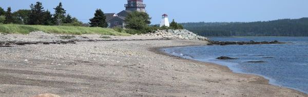
Boulder or cobble beaches are not exactly uncommon in the area of Oak Island. Here is a nice example from nearby Lunenburg, Nova Scotia (Figure 1). If this were covered with dirt over a few centuries, and if one were to come along and excavate a straight trench through it, one could very well conclude that there was a stone road there at some point.
Another issue is that on the opposite shore of the swamp, to the left of Figure 2 shows a clearly visible scattering of small boulders or large cobbles, and may look very much like the shore on which the road is located. Again as an archaeologist, I would want to dig a test trench on that other shore, to see if I find something similar to the road, or whether the stone road really is different.

Thinking back to the picture of the Lunenburg beach above, I would also want to widen the original trench to see if I am dealing with a straight line or with a broader scatter. Perhaps the COOI team are doing this already, but if so, we haven’t heard, and that makes it difficult for the viewer to evaluate the claim that there is indeed a road there.
As for the ox shoes, they are consistent with a stone road, but they are not evidence of it. There is a difference. If there is a road, it is not surprising to find ox shoes. Finding ox shoes, however, doesn’t suggest a road. It suggests that there were oxen, which is not surprising on an island used for farming for a few centuries.
And then there’s the searcher activity, of course. As commenter Marty writes below “Before, and during the construction of the causeway, all equipment, boilers, machinery etc. arrived by boat on the south shore. It would be no surprise that a road to the Money Pit exists to transport all this stuff.”
At the end of the last episode (S08E16), there is the revelation that the road may branch toward money pit area and away from the swamp shore. If it does, I hope the team does more than dig a linear trench to the money pit before they conclude that there is a road. I hope they also extend to either side to find unpaved areas.
In the end, it wouldn’t be surprising if there was a road, and the presence of a road would not be evidence that there is a treasure. It would be evidence that there was settlement, evidence of which is already plentiful and extremely interesting.

Before, and during the construction of the causeway, all equipment, boilers, machinery etc. arrived by boat on the south shore. It would be no surprise that a road to the Money Pit exists to transport all this stuff.
LikeLike
Certainly not surprising, I agree. Showing that there is though, is a different matter. I will edit the post to point to your comment.
LikeLike
That is possible too. It would have taken a fairly robust landing spot and wide/structurally sound haul road for this purpose. But then you would think that there would be pictures, records, and witnesses to this if this was the case – it was built in 1965 after all.
You are not Marty L. by any chance are you?
LikeLike
I would say that what you refer to as a stone wharf was either:
A) Just that – a stone wharf built off the extension of lot 14 after the subdivision of the island in the 1760’s, before the two drumlin islands became one when a beach barrier formed between the two islands and the swamp (a salt water marsh) formed – this would have been access to South Shore Cove for this lot, or
B) A stone haul road built at the bottom of lot 14 after the subdivision of the island in the 1760’s, after the two drumlin islands had already become one and the swamp was already in place – this would have been so lot 14 could access South Shore Cove across the corner of the swamp to what was likely their own stone-crib wharf built in the cove.
It just depends on when the swamp formed. It could have formed several hundred years ago and built up that much material given how the area is prone to storm surge and has seen many hurricanes in that time period. A conformation would be to pour over historic mapping for the area going back to early exploration to see if the island shows up on any maps as 2 instead of 1.
But for the “stone road” as you call it, I agree with you – this “road” skirts the treeline and follows the contours of the island at the upland interface, and is highly likely to be the original shoreline of that part of the island before the swamp formed and made the 2 drumlin islands one. This “road” looks nothing like the “stone wharf” and closely resembles pretty much all cobble coastline in the South Shore of Nova Scotia and most of its islands (I am from this area, a short drive up the coast, and am intimately familiar with this part of the province).
You would think those from the area, like the archaeologists, the geologist, Dr. Spooner, Billy the excavator operator and his crew would recognize the difference between a constructed rock road and the buried common natural shoreline of Nova Scotia.
Also, this “stone road” they postulate was used for the money pit runs north-west away from the money pit to the east. They are saying it may branch to the money pit, but why build the road away from the money pit then branch it off to travel upland then back over the hill to the money pit when you could have just built the road from the swamp to the east, along the shore, right to the money pit with little elevation change? But then logic is another thing they have never found on this island…
It also could have been a searcher road, possibly constructed by Nolan when he brought heavy equipment to the swamp (and on this side of the swamp) to excavate and drill, but it likely was built, for convenience, on the original shoreline. There should be enough photography, handwritten maps, and personal knowledge if this was the case.
But Oak Island has a long history of European activity, with early French colonists (1600’s), American ownership (early to mid 1700’s two men from New York were on the island doing “something” – may have been an illegal salt operation to avoid taxes given that they were in the fishing industry), then British and German military/settlers in the mid to late 1700’s – these works were highly likely related to homestead life on the island and have been simply lost in time, with little to no records of these works (just the shadows of those who lived there). To ascribe everything on the island to a mysterious, conspiracy-laden theory of a vast treasure and an attempt to cover up a hidden history is simply silly.
LikeLike
Good observations. Thanks.
LikeLike
Ungulates won’t walk over uneven jagged rock surfaces. Hooves don’t like and don’t work in rocks.
LikeLike
The builders of the road may have covered it with clay to resolve this issue – from what I understand there were several surface clay pits around the island used by a brick works on the island so the material would have been close at hand. I did not notice if there was a layer of hard compacted material over the road when they excavated it or not – or if it was all hydric soils above. Good point though.
LikeLike
In the latest episode, Miriam was also referring to the clay layer before they hit rocks and to look out for that. I do wish they would go into how the road was constructed a bit more.
LikeLike
Yes, very difficult to evaluate claims without sufficient information.
LikeLike
The stratigraphy in the cross section of the stone rd should tell if it is natural or man made
LikeLiked by 1 person
OK, here’s my theory about the Oak Island “road”. What lies below the “road” is the remains of a seawall originally built to keep the slowly rising sea level from flooding the entrance to an ancient Roman gold mine. At the end of the last Ice Age, soil containing gold was transported from northwest Nova Scotia and beyond, by rivers of fresh water runoff from the melting glaciers. An island was formed from the solids piling up on the bedrock at the outlet of the river. The Gold River, which still flows from the west toward Oak Island, was probably the conduit for the Island’s gold deposits discovered on the surface by the Roman explorers. Digging horizontally and deeper into the golden soil yielded rich deposits of gold for many centuries. But eventually the natural sea-level rise began to flood the mine entrances. One of the mine entrances was located between two hills on the island now known as Oak Island. When storm water began to flow into the mine entrance between the two hills, a seawall was built between them to prevent further flooding of the mines. Later a road was built on top of the seawall to provide access to the eastern side of the island as the natural sea-level continued to rise. As time passed and the natural ground water table rose above the mine floor level, new mining efforts ceased and the mineshafts were abandoned. The natural sea-level continued to rise and eventually overtopped the seawall road between the two hills and that area became the swamp near the eastern end of the island.
LikeLike
My theory, as expressed in my eight books on Oak Island (based mostly on historical documents) is essentially that Scots settlers, under the banner of the Knights Baronet of Nova Scotia, were in the area from at least 1623, leaving in 1632. Their leader, William Alexander, Jr., was given exclusive rights to all fur trading. The French explorer Denys wrote some time after the fall of 1632 that local Mi’kmaq would come down the two rivers near Oak Island and trade furs in what became known as Mahone Bay. I think there could have been a shoreline trading post near the stone wharf and that the wharf was used simply to dock small boats carrying furs, to be unloaded there.
I also think these same Scots could have buried a cache of valuables in the Money Pit assuming they would be returning soon. The French took over Nova Scotia and the civil war in Great Britain happened, not allowing them to return for many decades. See http://www.oakislandgold.com for more details.
BTW, I have appeared on Curse of Oak Island about a dozen times and have seen virtually every nook and cranny of the island. I’ve spoken numerous times with most of the people you see on the show and continue to provide information to them weekly.
LikeLike
I’m wondering if the stone roadway is composed of native/natural stone rather than ballast stones used in empty ships. Apart from the treasure aspects, I can’t see anybody coming all that way and returning home with an empty ship. If the stones aren’t natural, perhaps they should find where they come from?
LikeLike